Butterfly Guide
Click the images to see individual pages of the Butterfly Guide or download the PDF below.


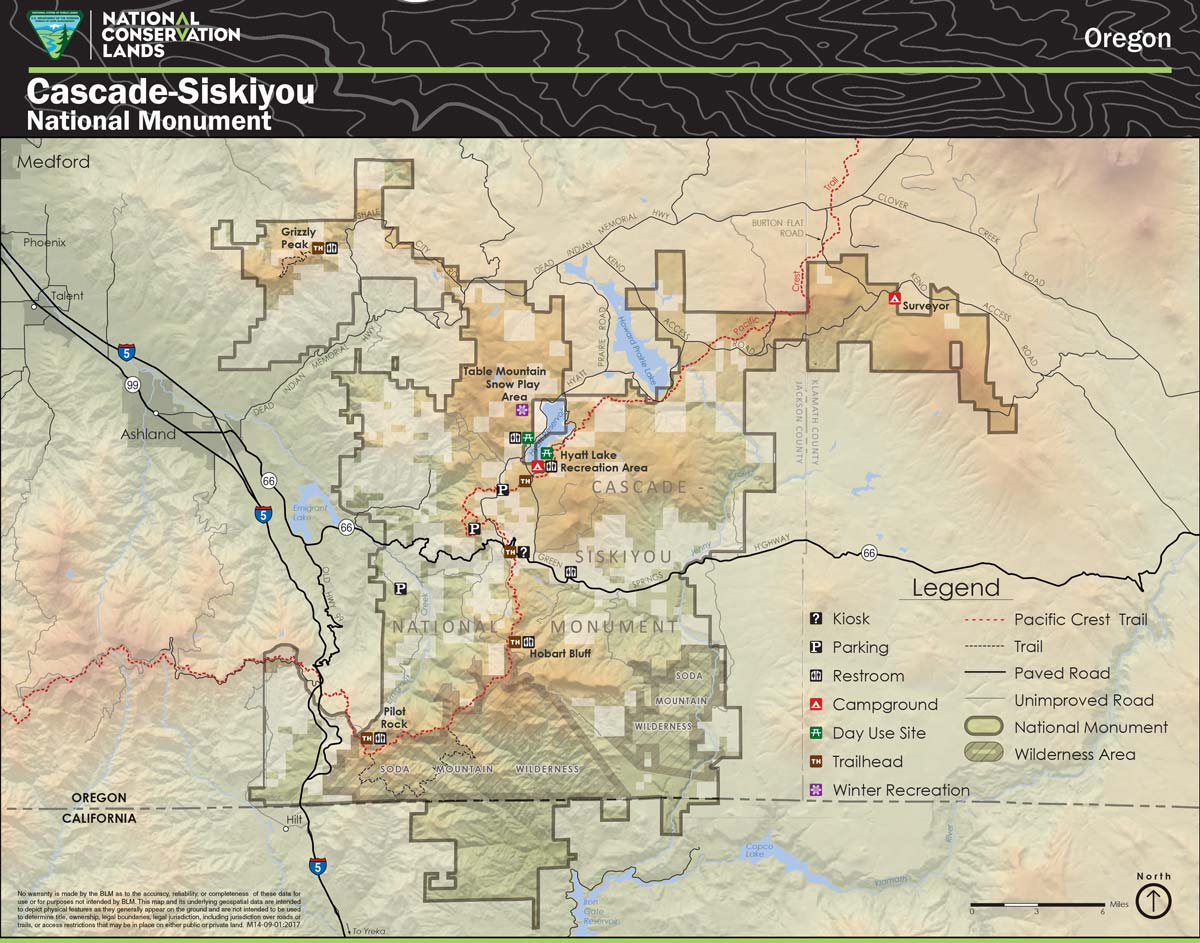
Places to Explore

Cascade-Siskiyou National Monument Contact Station
During summer weekends we have Monument Rangers at our Contact Station on Highway 66 next to the Green Springs Inn & Cabins. Rangers lead hikes and evening campfire programs at Hyatt Lake. Stop in at the Contact Station to see visual exhibits and get maps and brochures. Sign the visitor book and imprint stamp onto your journal or paper to remember your visit!
Additionally, BLM staff can answer questions about the Monument:
BLM Medford District Office
3040 Biddle Road, Medford
Tel. 541-618-2200
Open Monday-Friday, except holidays

Greensprings Loop Trail
Greensprings Loop Trail is an easy 3-mile loop (331 feet elevation gain) takes you up to Hyatt Lake through beautiful forest and fields. You can also hike this section of the Pacific Crest Trail!
PCT access points in the Cascade-Siskiyou National Monument (PDF)

Hyatt Lake Campground
Hyatt Lake Campground is the only developed campground in the Cascade-Siskiyou National Monument. Nestled in the Cascade Mountains in the northern corner of the monument, Hyatt Lake Campground provides opportunities for camping, hiking, fishing, and boating. Boating speed is restricted to wakeless. There are 70 campsites, as well as restrooms and shower facilities.

Hobart Bluff
Hobart Bluff provides stunning 360-degree views of the Rogue Valley. On most days, snow-capped Mount Shasta can be seen 75 miles away in northern California. The Monument’s converging ecoregions and the resulting plant diversity are on full display along the 1.5-mile hike up to Hobart Bluff. You’ll find common trees such as white fir, incense cedar, as well as plants more commonly seen in the deserts of the Great Basin such as sagebrush and western junipers.
Hobart Bluff Trail is an easy 2.5 mile out-and-back trail great for wildflowers and bird watching. At the top (413 feet elevation gain), enjoy beautiful views of Ashland, Pilot Rock and Mt. McLoughlin. Dogs are welcome but keep them on leash.

Pilot Rock
Pilot Rock (elevation of 5,910’) can be seen by travelers along the I-5 corridor. The Takelma people called it Tan-ts’at-seniptha, or Stone Standing Up. Pilot Rock was formed approximately 25 million years ago when magma oozed through a weak spot in the earth’s crust, but did not reach the surface. After the surrounding softer rock eroded away, it left an outstanding example of the inside of a volcano. Pilot Rock is composed mostly of volcanic andesite and shows the classic columnar joints.
Pilot Rock Trail is an 8.8-mile out-and-back hike that takes you on the moderate Pacific Crest Trail to steep Pilot Rock in the Soda Mountain Wilderness. This hike offers opportunities for hiking, backpacking and climbing. Dogs are welcome but must be on leash.

Grizzly Peak Trail
Grizzly Peak features a short hike that is long on rewards.
Grizzly Peak Trail is a family-friendly trail located 12 miles east of Ashland, winding through a mixed forest of fir and pine, passing through a burn scar, and providing outstanding views of the Rogue Valley and the city of Ashland. Be sure to continue on the loop trail past the top of 5,922-foot Grizzly Peak for the best views on the hike. Clear days offer outstanding views of the Cascade Mountains including Mt. McLoughlin, Mt. Shasta and Diamond Peak. In early summer, wildflowers put on a spectacular show along the trail.

Soda Mountain Wilderness
Soda Mountain Wilderness contains 24,100 acres including Pilot Rock and the Scotch Creek and Oregon Gulch Research Natural Areas. To keep the wilderness wild, mechanized activities are prohibited. Bounded by Pilot Rock on the west and the Box O Ranch along Jenny Creek to the east, the SMW invites backcountry exploration by prepared sojourners.
Soda Mountain Trail is a moderate 4-mile out-and-back trail that will take you 836 ft in elevation. This trail is open to hikers, dogs on leash and horses.

Pacific Crest Trail to Little Hyatt Lake
Little Hyatt Lake via the Pacific Crest Trail is a 3-mile out-and-back trail near Ashland, Oregon. Generally considered a moderately challenging route, it takes an average of 1 hour 22 minutes to complete. This trail is great for hiking and it’s unlikely you’ll encounter many other people while exploring. The trail is open year-round and is beautiful to visit anytime.
The Pacific Crest Trail winds over 30 miles through the Monument. Vehicle routes intersect with the PCT at Hobart Bluff, Pilot Rock, Greensprings and at about milepost 15 on Highway 66. Learn more about the PCT on the Pacific Crest Trail Association website.